Sunday, July 25, 2010

Shaping the System

When I was writing my last post on Point Reyes National Seashore, I was thinking it may have been the first National Seashore, which would have been interesting to point out. To find the answer to this question, I consulted my copy of The National Parks: Shaping the System. It turns out that it was the second, two years after Cape Cod. Pictured Rocks National Lakeshore, which I mentioned in the post, was indeed the first National Lakeshore.

I love this little book. As you might expect from the title, it is devoted to telling us when each park was added to the system, both in narrative and tabular form. It is interesting reading for a National Park buff like me, and it is an excellent reference book. One especially interesting entry, on the back cover, is the history of the NPS arrowhead logo over the years. If you would like a copy of the book for yourself, you can order it from the US Government Bookstore for $12.50 or you can access a PDF version at the National Park Service web site.

Saturday, July 24, 2010

Point Reyes National Seashore

Point Reyes National Seashore in California is an hour or so north of the Golden Gate Bridge. We recently took a vacation to San Francisco, and naturally I scheduled some time for my second visit to Point Reyes. The park is on the opposite side of the San Andreas Fault from the rest of the state. This would not be surprising to anyone who has looked at a map of the park. Millions of years ago it was by Los Angeles, and millions of years from now it will be in Alaska. Luckily for me, right now it is in Marin County.

Point Reyes National Seashore reminds me quite a bit of Pictured Rocks National Lakeshore in Michigan. They are both on huge bodies of water (the Pacific Ocean and Lake Superior), they both have cliffs that tower high above the water, they both have lighthouses, and they both have secluded beaches nestled between cliffs. The main difference is the plant life. Point Reyes is largely grassland and Pictured Rocks is largely forest. Also, there are large hills around Point Reyes, something you won’t find too much of in Michigan.

On my first visit in 1993, I only had a half day in the park. First I checked out the Bear Valley Visitor Center and walked the short Earthquake Trail. There is a fence along the trail that was split into two sections 16' apart by the 1906 earthquake.  The Point Reyes Lighthouse is a well-known landmark, so I made that my prime destination of the day. The location of the lighthouse is unusual in that you have to descend about 300 steps to get to it, presumably so it can be right at the edge of the cliff. The parking lot is some distance from the lighthouse, and you have to walk along the road to get there. Along the road are several trees that I assume to be cypress. As is usual for this part of the state, it was foggy that day. I got a nice photo of the trees and fog, which later won a local photography award.  I named the photo “The End of the World,” because that is what it really looked like. Interestingly, the fog cleared as I was at the lighthouse, and the trees just did not look the same on the way back. After checking out the North Beach, I drove to the Mount Vision lookout for a nice overview of the park and Pierce Ranch to check out the elk.

My recent visit was longer, with one full day (minus the drive from San Francisco) scheduled and the possibility of a second day. The second day was originally earmarked for visiting the John Muir National Historic Site in Martinez, but it turns out that it is closed on that day. So, the day became a contest between a second day at Point Reyes or a visit to Golden Gate Park in San Francisco. As you will see, the second day at Point Reyes won.

On the first day, we stopped at the Bear Valley Visitor Center and then stretched our legs on the Earthquake Trail. Then we drove up to Pierce Ranch to hike the Tomales Point Trail. The trail goes to the end of the point, which separates Tomales Bay from the Pacific Ocean. My wife did not want to hike the whole distance, so we decided to hike to the highest point for a 5-mile round trip. We think we did it, but it was hard to tell with the heavy fog. After finishing the hike and poking around the ranch, we went to nearby McClure's Beach. The trail through a canyon was beautiful, especially with flowers covering the canyon walls. At the end, the trail suddenly opened up to the ocean.

Next we visited the lighthouse. I was eagerly anticipating seeing the cypress trees again. They were still there. For kicks, I tried to duplicate my earlier photo from memory. I did a fairly good job with the composition, but the fog and light was just not the same. This one will not win any awards. On the way back up from the lighthouse I tried to walk up all 308 steps without stopping, but there was a section of ramp that was difficult and I had to stop to catch my breath. Maybe next time.

On the second day, we took the Bear Valley Trail from the visitor center to Arch Rock on the ocean. It was an 8-mile round-trip that was the easiest hike in the world. The trail was flat and wide and had no significant elevation changes until the very end. It was a nice walk through fields and forests and along little streams. The view at the end from atop Arch Rock was excellent, even with a touch of fog. I highly recommend this hike. 

 
My visits: June 1993, July 2010

Wednesday, July 7, 2010

Sequoia and Kings Canyon National Parks

Sequoia National Park and Kings Canyon National Park in California lie next to each other in the Sierra Nevada Mountains. Though separate in name, they are administered as one park. They are about 150 miles from Yosemite National Park, the subject of my previous blog post, so I visited all three parks in the same trip. This was my best hiking trip by distance, with 72 total miles. Out of the three parks, Kings Canyon was my favorite. Yosemite has grander scenery, but the hikes in Kings Canyon were superb and the scenery is quite good. I spent two days in Kings Canyon with a day in Sequoia squeezed between them. My book, National Parks of the Sierra Nevada, available on Blurb, contains pictures from this trip

I arrived at Kings Canyon National Park early on Thursday morning, and the first thing I did was check out the General Grant Tree. This tree is the second largest tree on the planet. It’s big. After staring at the tree for a while, I continued on Highway 180 through Giant Sequoia National Monument and back into the park. The road ends at the appropriately named Roads End Permit Station. Before reaching the end, I stopped at some viewpoints and at Roaring River Falls. Several trails begin at the permit station. (Permits are not required for day hikes.) I took the trail that follows the South Fork of the Kings River past Mist Falls and Paradise Valley for a 13-mile round trip.

The trail had rugged and beautiful canyon and mountain views along a raging river. It was a great hike. Mist Falls was pretty, but the biggest excitement on the trail was just ahead. On the trail just past the waterfall, I saw my first rattlesnake in the wild. I excitedly grabbed my camera, but I did not really want to wait for him to pose for me. I snapped one blurry shot and then moved on quickly. As if this weren’t amazing enough, I saw something even more amazing further up the trail. I am a very good hiker, but I do my share of huffing and puffing in the mountains. I saw a group of high school girls on the trail who were not huffing and puffing, but rather running up the trail. Not only were they running, but they were singing while they were running. Did I mention that we were at 5,000 feet and going uphill? It is a cruel fact of life that there is always someone better than you. I felt better when I came across two huffing and puffing college boys with whom I was able to share my amazement.


I  continued up the trail for a while until it reached Paradise Valley. The trail continues for many more miles, connecting with the John Muir/Pacific Crest Trail, but this was my destination. At this point the river was flat and smooth and there was plenty of flat space between it and the canyon walls. After enjoying the shade for a while, I started the return hike. My next stop was the Cedar Grove Lodge to check in and get dinner at the snack bar. After dinner, I walked 1.5 miles along the river and Zumwalt Meadow. The flat green meadow was a nice change from the rough gray canyon.

Friday was my day for Sequoia National Park. Of course, the first thing I did was visit the General Sherman Tree, the largest tree on Earth. It was quite impressive, and a real treat for a tree-hugger such as me. I combined this site with the Congress Trail and Crescent Meadow for a seven-mile hike. Along the Congress Trail are groups of trees with names such as the Senate Group and the House Group. I did not see a Windbag Group. Crescent Meadow has been hailed by John Muir as a “gem of the Sierras.” It is a nice, mile-long meadow among the giant trees. Many of the sequoias are old and gnarled, but across the meadow I spotted one nearly perfect tree. Near the meadow is a rather unusual sight: Tharp’s Log, which is a house made within a single fallen sequoia.

When I was done with this hike, I headed back up the road towards Grant Grove where I would be staying for the night. On the way, I stopped for a 3.5-mile round trip hike to the top of Little Baldy, one of the peaks along the road. There was an excellent mountain view from the top. Though I enjoyed my day at Sequoia, the park did not really thrill me. I might have a different view if I were a backpacker. After all, Sequoia NP is the home of Mount Whitney. Interestingly, you can't see Mount Whitney from the park without substantial hiking but you can see it from Lone Pine, near Manzanar National Historic Site, on the opposite side of the Sierras. Still, a visit is definitely worthwhile to see the General Sherman Tree, and it is a very short drive from Kings Canyon.

My last day was Saturday, and though I did not realize it at the time, I had saved the best for last. The Redwood Mountain Loop was a great walk in the woods, with the bonus of giant sequoia trees and a descent into a canyon with accompanying views. The trail starts high with the canyon and mountain views and then descends into the woods. There are several interesting hollow trees, including a fallen one through which the trail goes lengthwise. My favorite part of the hike was the lush forest where the trail crosses Redwood Creek. One thing that I love is a nice walk in the woods, and this trail does not disappoint. Though this was my favorite hike of the trip, there were two others that were very close: the Mist Falls/Paradise Valley hike in Kings Canyon National Park and the Lyell Canyon hike in Yosemite National Park. After completing the hike, I stopped at the Redwood Mountain Overlook and then returned to the Grant Grove Lodge to prepare for my return trip to San Francisco. I had only six parks left to complete visiting every National Park in the lower 48 states.

My visit: August 2006

Tuesday, July 6, 2010

Yosemite National Park

By mid-2006, I had only nine parks left in my pursuit to visit every National Park in the lower 48 states. There were still two big-name parks left: Glacier and Yosemite, the latter being perhaps the biggest name of them all. It was time to go to Yosemite.

Yosemite National Park in California is in the Sierra Nevada Mountains, a mountain range much more impressive than one might think. People in the East such as me tend to think of the Rockies when they think of great mountains, but Mt. Whitney, the highest peak in the lower 48, is in the Sierra Nevada. Many of Ansel Adams’ famous photographs were taken there. John Muir named his Sierra Club for them after spending much time “sauntering” among them. I first saw the Sierras rising over the Owens Valley on a visit to Manzanar National Historic Site in 2000, and I was quite surprised and impressed. Besides Yosemite, Kings Canyon National Park and Sequoia National Park are in the Sierra Nevada, and they will be the subject of my next blog entry. I have a book, National Parks of the Sierra Nevada, available on Blurb, which contains pictures from this trip. Speaking of books, The Moon Handbook for Yosemite by Ann Marie Brown is an excellent guide book. She is also the author of my favorite hiking guide, Day-Hiking California's National Parks.

Yosemite National Park is impressive, but the thrill was toned down a bit for me because of the excessive hype the park receives. Even Yosemite cannot live up to its own hype. However, it was indeed a thrill to stand in front of Half Dome and El Capitan. They are, of course, immediately recognizable. The park is beautiful, and the rounded granite mountains and cliffs are unlike any I have seen before. I tend not to use the term breath-taking, but there is no other term to use when standing at Glacier Point looking down at the whole valley. Despite the hype, Yosemite is an impressive sight and a great National Park.

San Francisco, about 200 miles from the park, is the obvious place to fly into when visiting Yosemite. I arrived late in the day on a Saturday, so I drove to Oakdale, about halfway there, to shop for groceries and spend the night. On the first night of a hiking trip I stop to get food that requires no refrigeration so I can carry it in my daypack for lunch. Slim Jims, bagels, and granola bars are among my favorites, though for my next trip I may try pouches of tuna. I also get breakfast items that may or may not require refrigeration depending on the motel I am staying at.

On Sunday morning I continued to the Hetch Hetchy entrance of the park. I chose that entrance so I could get miscellaneous sightseeing out of the way before starting my serious hiking in the Tuolumne Meadows area. Hetch Hetchy Valley has been a lake since about 1923 when the O'Shaughnessy Dam was completed to supply water to San Francisco. They may take away my Sierra Club membership for saying so, but I liked the scenery and I think the loss of the valley was not such a great loss. An alpine lake, real or impoundment, is a beautiful site. There are plenty of before and after photos on the internet for you to decide for yourself. From the parking area, there is a trail that goes over the dam and then around the north side of the lake. I took this trail past Wampana Falls and back. I especially liked the view of Kolana Rock.


After hiking at Hetch Hetchy, I drove to the Tioga Road. My destination was Mono Lake on the other side of the mountains. I had wanted to see this ever since I purchased Pink Floyd’s Wish You Were Here many years ago. If you do not understand this reference you are too young, but please continue reading anyway. Of course, the journey was just as important as the destination, since the Tioga Road crosses Yosemite National Park. The first exciting thing I saw was Half Dome from Olmstead Point. It was recognizable as Half Dome, but it looked very different than the usual view from Yosemite Valley. This was my first “Wow, I’m in Yosemite” moment. My next stop was Tenaya Lake, where I stopped to eat lunch. Tuolumne Meadows was next, and eventually I left the park and headed to Mono Lake. I stopped for gas in Lee Vining and got totally ripped off. Gas was about $3/gallon at the time, but it was $4 there. Travelers, beware!


Mono Lake was just as cool as I expected. I’ve never seen anything else quite like all the tufa formations sticking out of the lake. After poking around there for a while, I returned to the Tioga Road and headed back through the park to Yosemite Valley, where I was staying at Yosemite Lodge. I would have preferred to stay closer to Tuolumne Meadows where most of my hiking would be, but accommodations are tough to get at Yosemite. I was lucky to get even that since I dawdled and made my reservations only ten months ahead of time. I stayed in one of the smaller buildings of the Lodge. The $170 room was decent, and it had a refrigerator. Yosemite Falls was easily visible from the grounds. Of course, I spent some time wandering around the valley to see Half Dome, El Capitan, and the other well-known features. My first view of El Capitan upon heading into the valley earlier in the day was somewhat amusing (at least to me). I was driving along the road taking in the beauty of my surroundings when suddenly there was a huge wall of rock more or less in front of me. “What the heck?” I then realized that it was El Capitan, and I was too close to see the top. It was much bigger than I had expected.

Monday was my first day of real hiking, so I got up early to head to the Clouds Rest trailhead near Tenaya Lake. The drive from Yosemite Valley is rather long and takes over an hour. Clouds Rest is a peak further up Tenaya Canyon than Half Dome, which is more or less at the junction of the canyon and Yosemite Valley. Clouds Rest has what many hikers consider to be the best summit view in the park. I haven’t been to all of them, but I sure cannot disagree. Not too far into the hike, there was a beautiful mirror-like pond. It took me a while to pull myself away from it. As I hiked higher, I passed through both woods and open areas from which the view kept getting better. The final ascent is over step-like granite with drop-offs on both sides – totally cool. The view from the top is as advertised, and it is indeed spectacular.

After seeing the view from Clouds Rest, I made my final decision not to hike Half Dome. The view would be much the same, and I consider Half Dome to be a dangerous hike because of the combination of crowds and cables. After hiking back to the trailhead, I returned to Yosemite Valley to view El Capitan and Bridal Veil Falls, eat dinner, and relax. I ate dinner each night at the lodge food court. The food was good and value was excellent for a National Park, where they know they have a captive audience.

On Tuesday Morning I returned to the Tuolumne Meadows area to hike Lyell Canyon. The trail followed the Lyell Fork of the Tuolumne River. It was quite chilly that morning, and at the beginning of the trail steam was rising from a small creek and dew on the grass made it appear silver. I hiked approximately ten miles, round trip. I knew I would not be able to hike to the end of the canyon and back (24 miles) in my allotted time, so I would have to choose a turn-around point. It is difficult planning a hike like this, because the temptation is to keep going until I reach the end. Turning around is difficult, even if it is in the plan. I reluctantly turned back when I thought I had gone five miles. For the portion I hiked, I would call it more of a valley than a canyon, as it was relatively wide and flat.

This hike turned out to be my favorite in the park. I was in a beautiful valley with a beautiful clear river running through it. Being from Michigan, I am genetically programmed to love trees and water over rock. After completing my hike, I popped over to Tuolumne Meadows and walked to the top of Pothole Dome to get an overview of the meadow. Then I returned to Yosemite Valley for dinner and to spend more time among the famous sites. The highlight of the evening was stopping at Tunnel View. This is a superb spot to view the valley all the way down to Half Dome, and is one of the obligatory stops for photographers. Returning to the valley floor, I got a nice sunset view of Half Dome.


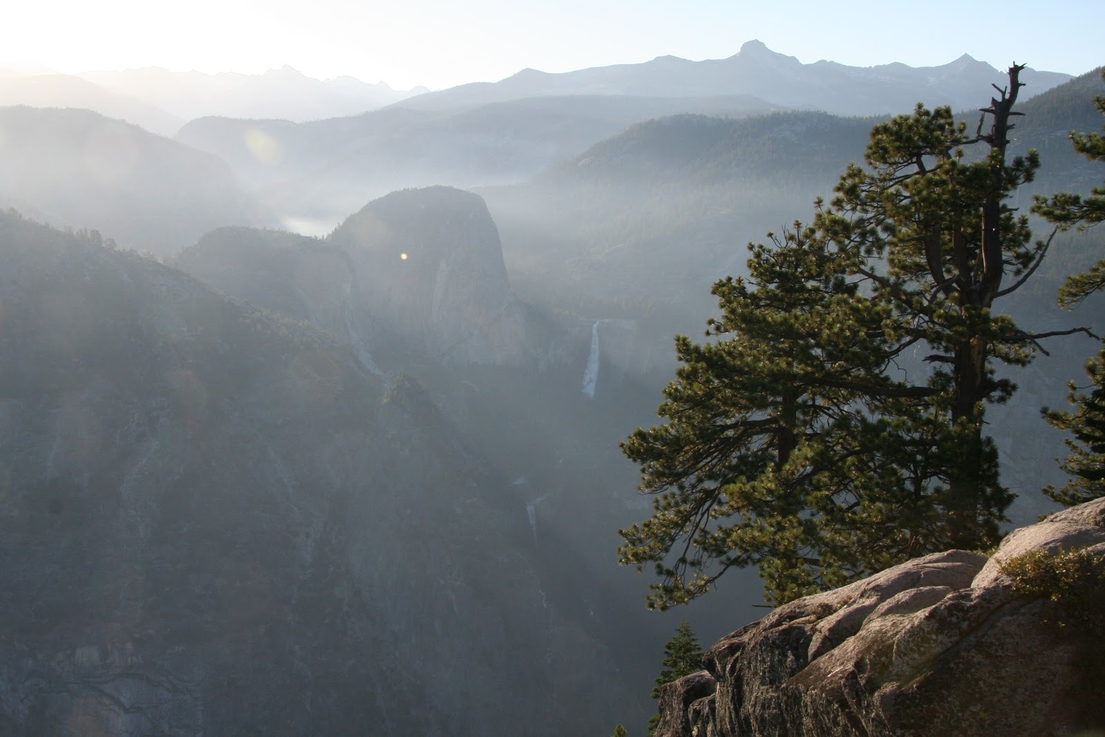
Wednesday was my final day in Yosemite. Since I would be leaving through the south entrance, I saved the Glacier Point area for today. My first stop was at the end of the road at Glacier Point. The view was spectacular, one of the best I have ever seen. I could see Yosemite Valley, Half Dome and Clouds Rest beyond it, Vernal and Nevada Falls, Yosemite Falls, El Capitan, and mountain scenery for miles around. My only regret on this trip is that I didn’t take the shuttle up to Glacier Point and then hike back down to Yosemite Valley. It would have been a spectacular hike. Oh well, I guess that’s what next time is for.


After taking in the scenery at Glacier Point, I started back. Washburn Point is about ¾ mile down the road, and the views are also very good, but not quite as all-encompassing. The view of Half Dome from there is rather unusual in that it looked very skinny. Next I hiked a 2-mile round trip to Taft Point and the Fissures. The Fissures, as you might guess from the name, are big cracks in the cliff near Taft Point. The view of El Capitan was very interesting. It has a much different shape from up there than it does from the valley floor. I also made the 2-mile round trip to the top of Sentinel Dome for a slightly different view. Finally, I took a short walk to McGurk Meadow for a change of pace.

It was now time to leave Yosemite. I passed through the south entrance and stopped later in Oakhurst for dinner and an overnight stay. I had dinner at El Cid, a Mexican restaurant that had the biggest flan I have ever seen. I almost couldn’t eat it after my huge and tasty dinner. The next morning it was time to head to Kings Canyon and Sequoia National Parks, the subject of my next posting.

My visit: August 2006