Glacier National Park in Montana is my favorite National Park. Its beauty is almost indescribable, and the hiking is superb. As I was leaving the park during
my first visit in 2007, I was already making plans to return. I made good on those plans this past September.
This time I flew into Calgary, which is about 200 miles from the park. This presented a bit of a dilemma during the planning stage, as Calgary is only about 80 miles from Banff National Park, which I had never visited. I resisted the urge of mission creep and made my plans for Glacier. After picking up my rental car and stopping at Safeway to get some groceries for the week's breakfast and lunch, I drove to Glacier. The weather was rather gray and rainy, and unfortunately this would be true for most of the trip. My destination for the night was the
Rising Sun Motor Inn, a few miles into the park on the St. Mary side. This was fortunate because they told me at the gate that it was snowing at Logan Pass, and the road was closed there.
On my first visit, at the exact same time of year, the weather was sunny and warm, and I could hike whenever and wherever I pleased. The rainy weather and a snowline of about 7,000 feet would make planning a hike much more difficult this time. I spent quite a bit of time Sunday night deciding what to do tomorrow. As it turned out, this would become a nightly ritual. I had two main goals on this trip: the Dawson-Pitamakan Loop in the Two Medicine area and the Highline Trail to the Grinnell Glacier overlook. Dawson-Pitamakan tops out at 8,000 feet, and there are knife-edges to traverse, so it looked like I would not be doing that one, at least until later in the week. The Highline Trail begins at Logan Pass and tops out at about 7,000 feet, so waiting a day or so might be good. I decided that I would do the
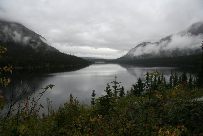
Grinnell Glacier Trail at Many Glacier. I had hiked this trail the last time, and it was one of the best hikes I had ever taken. This 11-mile out-and-back trail tops out at about 6,500 feet.
Early Monday morning I headed to
Many Glacier. The weather was generally gray and rainy, but there was a bit of blue sky, and the sunrise on the mountains as I headed into the valley was beautiful. That would be the last time I saw the sun that day. Although I prefer hiking in good weather, the gray clouds and snow gave everything a totally different feel than the last time, and it was beautiful in its own way. I never did see the top of the Garden Wall or the Gem, but the scenery along the trail was magnificent as usual with the snow on the mountains making them look more imposing. I looked for the huge wildflower patch I had seen last time, but it was too cold this year, and they were gone. The last quarter of the trail had some snow along the trail, and there was snow on the trail at the final approach. Upper Grinnell Lake was iced up, so I did not dip my feet in this time. On the return trip I saw a mountain goat close-up. I ate my lunch at the lower elevations near Lake Josephine.
After the hike, I took the
Going-to-the-Sun Road across the park to Apgar. By then it was raining, but the wetness brought out the color in the rocks and trees. The snow on the mountains at Logan Pass was beautiful. The visibility across Lake McDonald was poor, but it was still pretty. I decided to return to the east side via US-2, which hugs the park boundary, so I could check out the view from there. There was nothing exciting, but at least it is a faster road the Going-to-the-Sun. I got a big kick out of driving on US-2 in the mountains, since US-2 is the same road that goes across the Upper Peninsula (UP) of Michigan. Once I returned to the St. Mary area, I headed for my favorite non-hiking spot:
Two Sisters Café. I had my usual buffalo burger with a big onion on it. They did not have the home-made tortilla chips any more, but the Cajun-spiced fries were a very worthy successor.
I could see the tops of the mountains on Tuesday morning, so I decided that it would be a good day to take the
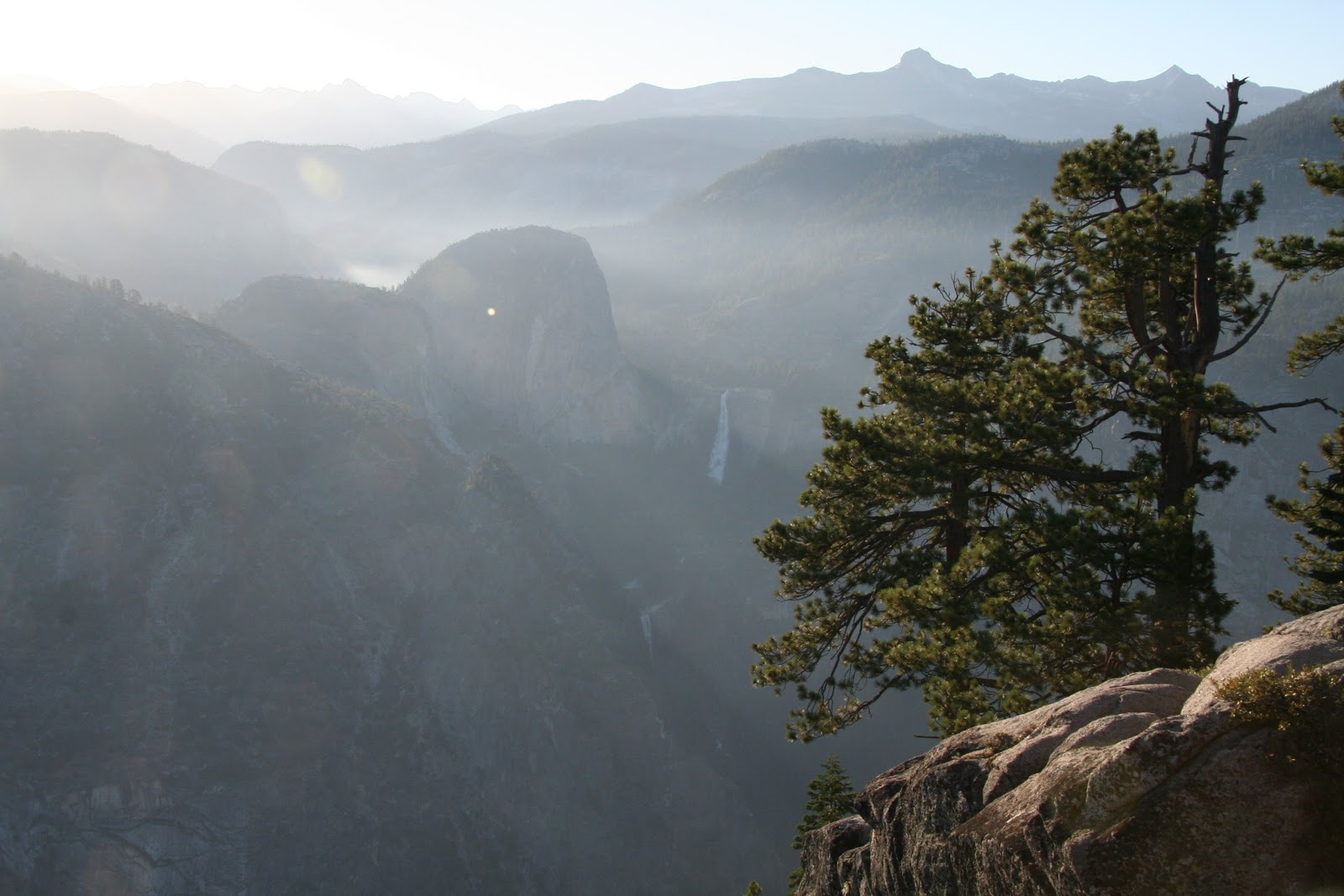
Highline Trail to the
Grinnell Glacier overlook, a 15.2-mile out-and-back hike. I did not know about that little side trail on my first visit, but as soon as I found out about it, I put it on my list for next time. I had seen Grinnell Glacier from glacier-level, and I absolutely had to see it from up on the Garden Wall. The Highline Trail sits high up the Garden Wall and in places is a thin shelf on the cliff. In other words, a great trail for views. As I walked along the trail, Heavens Peak and the Livingston Range came into view. As the sun rose, it touched the tips of the mountains with its light. It was one of the most beautiful sights I have ever seen. The trail was mostly clear, but once in a while I had to walk on some snow. This was a test of nerves in some spots, as a fall would have been very long indeed. In addition to the scenery, I saw bighorn sheep and mountain goats.

Eventually, Granite Park Chalet came into view. It reminded me of Switzerland, where they commonly have buildings in the mountains. Soon, I was at the trailhead for the Grinnell Glacier spur. It took me quite a while to hike the 0.6 miles to the overlook, both because of the altitude and because of the snow on the trail. The goal was absolutely worth the work. I could look down at
Grinnell Glacier, the Salamander, and Upper Grinnell Lake. I could see the spot where I had been standing the day before. Someone who had hiked from the Chalet took my picture there, and then I ate my lunch. It really was too cold and windy to eat lunch there, but how often would I have a chance to eat in such a spot?
The return trip was interesting both for a bad reason and a good reason. The bad part is that my left knee started hurting on the way down from the overlook. My knee has never bothered me before, but the combination of my age and suddenly demanding that my body traipse up and down mountains was too much. I longed for the days when I was 30 and I could do anything I wanted to my body and its only protest would be sore muscles the next morning. Oh well, I’ll just have to open up my wallet and get some trekking poles. I continued the hike at a slower pace.
The exciting thing came later down the trail. There was a curve up ahead and some hikers coming towards me mentioned
grizzly bears that were on the trail but had moved off. I put my senses on high alert and continued. I rounded the curve and saw…nothing. Of course I had to relay the news to the next hiker coming towards me, and as we were talking he spotted three grizzlies below the trail. I snapped a picture and moved on. As I explained to my fellow hiker, my policy around dangerous animals is take a quick shot and get the heck out of there. At least this one came out better than my blurry rattlesnake at
Kings Canyon National Park. The rest of the hike was uneventful, and it started raining as I was approaching the parking lot. I got in my car and it started really raining. I did a little weather victory dance as best I could while strapped into the driver's seat and then headed to Two Sisters.
Tuesday evening was the time to plan for Wednesday’s hiking. This was the biggest planning challenge I have ever had. The weather showed no sign of getting better. I was at a mountain park, but I had to take a low trail because of the snow and a level trail because of my knee. I had several hiking guidebooks to help me, and I did indeed find such trails. This was the classic blessing in disguise. I ended up taking great trails that I would have ignored under better conditions.
Wednesday morning started gray again, but at least I could see the tops of the mountains. This would turn out to be the best weather day, with some actual blue sky scattered throughout the day. My first hike was to
Grinnell Lake, a 6.8-mile out-and-back hike. I had seen Grinnell Lake several times from high above, but this time I would see it from lake level. I would also be able to see
Grinnell Falls from below.
The trail begins in the parking lot of the Many Glacier Hotel and passes Swiftcurrent Lake and Lake Josephine before ending at Grinnell Lake. The trail was quite muddy, but also quite level. The weather may have made for bad hiking, but it made for great photographs. It doesn’t get much better than blue sky with wisps of clouds among the mountains. It was a beautiful hike. The exciting thing on the trail besides the spectacular scenery was the bridge crossing a small creek not too far from Grinnell Lake. It was made of wood planks and was suspended with rather thin steel cables. Every step sent the bridge violently bouncing. I’m scared of pretty much nothing, but crossing that bridge was something I was not looking forward to repeating on the return trip. After spending some time and having a snack at the lake, I returned to the trailhead. I had lunch at a picnic table at a nearby picnic area.

My next hike of the day was Beaver Pond, a 3.4-mile loop very near the St. Mary entrance. It was a nice enough hike through the woods and along St. Mary Lake, but not really Glacier-quality. After dinner at Two Sisters I hiked to
St. Mary Falls, a 1.6-mile out-and-back hike. St. Mary Falls is my favorite in the park. On the way down, I saw a deer right on the trail, and ran into her again on the way back.
Thursday was a rainy day, and my hike would be the 7.2-mile
Two Medicine Lake Loop. I headed towards Two Medicine hoping that the rain would stop. The rain and fog on the thin and winding SR-49 was quite enough excitement for the day. As I pulled into the parking lot at Two Medicine Lake, the rain had pretty much stopped. I started my hike in a clockwise direction. The trail was quite pleasant, with several clearings and ponds beside it for the first mile or so. At that point, it became a nice walk in the woods with an occasional glimpse of the lake. I could not see too many mountains with the low clouds, but once in a while I could see craggy peaks poking through the mist, much like an ancient Chinese painting. I had to cross another one of those shaky bridges, but this was a loop so I would not have to do it again.

It was on this trail that I found out what unpleasant hiking really is. At the far end of the loop, the views of the lake open up. There are blueberry or some such shrubs along the trail. Although it wasn’t raining at the time, the shrubs were wet, and before long my pants and boots were soaked. Soon, the only sound I heard was squish, squish, squish. Then it started raining. And it was cold. I switched to my Seattle Sombrero and put on my gloves. At the side trail to the boat dock, I sat down and wrung out my socks. On many hikes, once you reach the big scenic destination all that is left is the trudge back to the car. After the highlight of the beautiful lake view, there was a long cold and wet trudge. Complaining is fun, but seriously in all my years of hiking this was the first time I had to hike in such conditions. I consider myself lucky. My mother would say that it builds character.
I survived the hike and ate my lunch in my car. After lunch, I headed to Browning to check out the Museum of the Plains Indian. This was not the most impressive museum, but there was a display of formal and ceremonial clothing that was impressive indeed. Even more impressive was my dinner at Two Sisters.
Friday was my last day, and I decided to stop at
Waterton Lakes National Park on my way back to Calgary. There was a bit of sun in the morning, and this time I was able to see Chief Mountain, which was shrouded in fog on my previous visit. Although it was early September, the light, the trees, and the air all had a pleasant autumn feeling. It was a nice drive to the border crossing. Once at Waterton, I drove the Akimina Parkway to Cameron Lake and hiked the 2.2-mile out-and-back
Cameron Lake Trail. The weather was not so nice any more. I ate my lunch at the end of the trail. Then I drove the Red Rock Parkway with the intention of seeing Blakiston Falls. It started raining, and this time I had had enough. I turned around and headed to Calgary.
Though there is a bit of complaining in this post, I certainly enjoyed my visit. In fact, this visit cemented Glacier in place as my favorite National Park. There is often great beauty in bad weather. Also, I was able to see Glacier under totally different conditions than in my previous trip. Snow makes mountains more imposing. Wetness brings out color. Gray skies completely change the feel of a place. Given the choice, I would have asked for warm sunny weather, but I have now been privileged to see different faces of Glacier National Park. Its awesome beauty shines through in any condition.
My visits: September 2007, September 2010